Analyses
Four studies were conducted in 2023 and 2024. These describe the current situation in the Kop van Drenthe region with regard to the water system (the ISA), nature (the LESA), agriculture, and the landscape (AAC – earth sciences, archaeology, and cultural history). We summarise them below.
1. Integrated system analysis Eelder-Peizerdiep (ISA)
How does the water system of the Eelder and Peizerdiep work?
The streams of the Peizer and Eelderdiep system flow northward from the Drents Plateau. The Fochteloërveen flows into the Peizerdiep. The stream valleys lie between the glacial hills. The streams are mainly fed by rainwater. Seepage water in the stream valleys comes partly from the hills and partly from deeper sources. In summer, water from the Noord-Willems canal is important to keep the streams flowing. The lower reach consists of peatland with agriculture and the De Onlanden nature reserve.
The soil in the Kop van Drenthe consists of different types, such as boulder clay and pot clay, which influence groundwater flows. Stream valleys are filled with peat and drained for agriculture, which ensures rapid drainage of seepage water and little water storage.
Main problems
- Current land use and climate change are disrupting the water and soil system.
- Historical agricultural practices pollute the water system with fertilisers.
- The water in the streams is too rich in nutrients for the desired poor-nutrient nature conservation goals.
- Crops such as corn and potatoes and coniferous forests evaporate a lot of water.
- Without measures, climate change will lead to more flooding and drought.
Key ecological factors
- To restore the natural water system and increase biodiversity, five things are important: water drainage, weirs, the shape of watercourses, shade, and the leaching of nutrients.
- Fish and other aquatic animals that thrive in flowing water benefit from sufficient flow velocity and shade.
2. Landscape Ecological System Analysis (LESA)
The Kop van Drenthe has stream systems that mainly drain water. Transitions are often interrupted. The aim is to better connect parts of the streams so that the water system works more effectively.
Issues
- Wide, deep streams cause desiccation.
- Ditches and deep streams prevent seepage in the root zone.
- Drainage and changing precipitation patterns reduce deep seepage.
- Climate change increases drought; agriculture requires more groundwater.
- Eutrophication deteriorates water quality.
- Peat decomposition lowers the soil and causes characteristic species to disappear.
What is needed?
- Hydrological restoration: raise groundwater levels, reduce drainage, make better use of seepage, keepe peatlands wet.
- Improve water quality.
- Adjust land use to reduce environmental burden.
Upper course of the streams and Fochteloërveen
The upper course used to be a marsh, but now the water flows away too quickly and dries out. In the summer, it receives water from outside sources. The aim is to reduce dependence on this water, improve flow, improve water quality, and retain water in the Fochteloërveen.
The ridges
Dry in summer, wet in winter. Nature benefits from ecological connections, restoration of natural transitions, and combating desiccation and nitrogen deposition.
Middle course of the streams
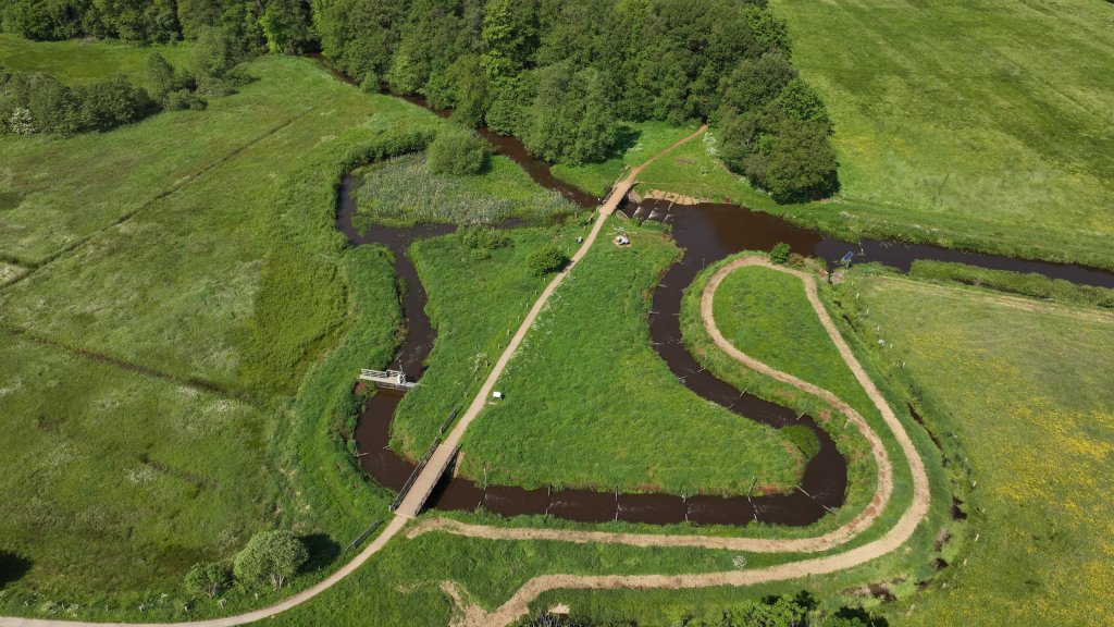
Streams have been straightened, widened, deepened, and dyked, resulting in rapid drainage and desiccation. Restoration measures: restore meanders and make streams shallower. Promising areas: Grote Masloot, Middenloop Peizerdiep, De Onlanden, Oostervoortsche Diep, Groote Diep, Hazematen.
Lower course of the streams and De Onlanden
The water here contains too many nutrients and crop-protection products. There are also insufficient ecological connections. The Masloot polder offers opportunities for meadow birds. Restoration of the water system in Elsburger Onland could improve hay meadows.
3. Agricultural analysis
The Kop van Drenthe is a varied agricultural area due to its location between three foothills of the Hondsrug. Significant differences in relief and soil type result in diverse water management and types of farming, such as livestock farming, arable farming, fruit growing, flower bulb cultivation, and tree nurseries.
Soil and water system
- South: valley soils/high moorland excavation around Fochteloërveen.
- Centre: stream valley and esdorp landscape with wet stream valley soils and essen (field complexes) around villages.
- North: lowland moorland.
Agricultural land
Water management is tailored to agriculture, with redesigned stream valleys to create a natural water system. Some agricultural land has been converted to nature areas. Measures are in place to ensure stable water levels.
Possible solutions:
- Improve the water-retention capacity of sandy soils.
- Improve soil structure to prevent compaction.
- Retain more water in the system.
- Eliminate bottlenecks caused by waterlogging.
- Adapt grass varieties and crops to spread risk.
4. Earth sciences, archaeology, and cultural history (AAC report)
The cultural-historical landscape in the Kop van Drenthe has been drastically altered by human intervention. Examples include the reclamation of heathland, the straightening of streams, and the construction of drainage ditches and canals.
Tasks
- Drainage in stream valleys damages peat soils, which form an important cultural-historical archive.
- The connection between the upper, middle, and lower courses of stream systems is not always apparent.
- Tree species that are sensitive to extreme weather conditions are dying, which affects the recognisability of the landscape.
- Filling in ditches affects the recognisability of the landscape.
Opportunities for the future
The vision for the future of the Kop van Drenthe region explores how water-management challenges can be combined with the reinforcement or restoration of the cultural-historical landscape.
More information analysis documents
Are you interested in the analysis document with the more detailed summaries? Please refer to the Schedule and Documents page.