Lake Paterswoldsemeer cycle route (Dutch only)
The work on lake Paterswoldsemeer will be completed in March 2025. The Noorderzijlvest Water Authority has taken various measures to improve water quality. Are you interested in the changes? We have put together a special tour of lake Paterswoldsemeer. View the cycling map here and a number of highlights along the cycle route, such as the fish passage and fish forests, the newly constructed forest sand path, and the nature-friendly banks. The route is also ideal for walking.
Background information
Between 2018 and 2024, the Noorderzijlvest Water Authority took various measures to improve the water quality of lake Paterswoldsemeer. To celebrate the completion of the work, a cycle route has been created. On a ride around lake Paterswoldsemeer, you will learn more about the measures that have been taken, iconic highlights, and cultural-historical sights. Enjoy your bike ride!
What can I see along the way?
Read more below about the twenty important sites along the cycle route and the impact of the implemented measures on water and nature.
View the route
Are in interested in the route? View the cycling map here and a number of highlights along the cycle route, such as the fish passage and fish forests, the newly constructed forest sand path, and the nature-friendly banks.
1. Weir with fish passage
In 2021, the weir next to the Meerschapsboerderij farm was relocated and widened, and the culvert under the cycle path was enlarged. This allows more water to be drained from lake Paterswoldsemeer. Next to the weir is a fish passage, consisting of chambers connected by openings. These create a gentle current and bridge the difference in height, allowing fish to swim upstream easily.
2. Meerschapsboerderij
The old farmhouse on Winterpad, built in 1925, houses the Meerschap. This is the organisation that deals with the management and maintenance of lake Paterswoldsemeer, lake Hoornsemeer, Hoornseplas, and surrounding areas. Since the 1970s, the farmhouse has served as a workplace for supervisors. In 1990, the building was renovated and has since also served as the Meerschap's office.
3. Winterpad and nature-friendly riverbank
A nature-friendly bank has been created along the Winterpad and behind the Meerschapsboerderij. This bank provides a shallow wet zone for bank and aquatic plants. This has created more habitat for aquatic and other animals, and the plants improve water quality.
4. Wall House #2
In the 1970s, American architect John Heiduk designed several Wall Houses, only one of which was actually built. In 2011, Wall House #2 was constructed on lake Hoornsemeer. The design features an enormous wall measuring 18.5 metres wide and 14 metres high. Since 2016, the Groninger Museum has been managing the house. It is open to visitors on weekends from April to October.
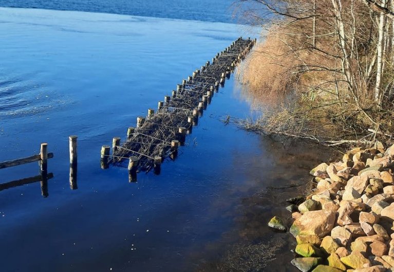
5. Nonnengat
When you cycle across the bridge to the island of Nonnengat, you will see fish forests between the islands. Fish can hide and spawn in these bundles of branches tied between wooden poles. These fish forests close off the area between the islands, creating a resting area for fish and animals behind them. The second bridge, between Nonnengat and the mainland, has been replaced by a dam with a culvert for the same reason.
6. Halve Manen
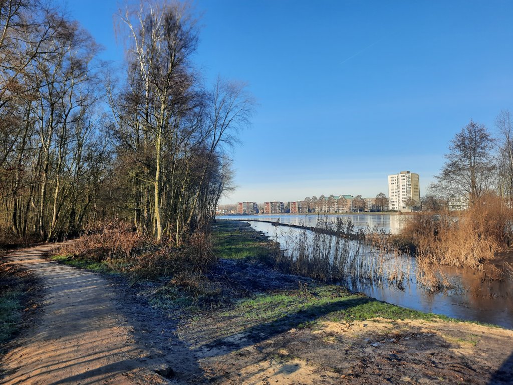
The Halve Manen area was used as a dredge-spoil depot in 2014. In 2024, it was reconnected to the lake, allowing it to develop further as a nature-friendly zone. As a result, Halve Manen will contribute to improving the water quality of lake Paterswoldsemeer and provide additional habitat for aquatic animals. A forest sand path has been constructed so people can enjoy nature too.
7. Jetties with fish hotels
There are jetties on the east side of lake Paterswoldsemeer. These have been renovated and seven of them are equipped with fish hotels. These offer fish a safe place to shelter and spawn.
8. Gate Tower Clio
In 1990, the city of Groningen celebrated its 950th anniversary. To mark the occasion, ten city markers (works of art) were installed at the city's access roads, referring to the old city gates. Along the A28 motorway stands Gate Tower Clio by Kurt W. Forster, an electricity pylon with seven metal flames representing the weekly cycle. On Monday, one flame is visible, and on Sunday, there are seven. The number 10.40 also lights up, referring to the year 1040, when the city was first mentioned.
9. Nijveensterkolk lock
Willem Albert Scholten, the Netherlands' first agricultural industrialist, built factories for potato starch, strawboard, and sugar syrup in the early 19th century. His son Jan Evert, a water sports enthusiast, marked lake Paterswoldsemeer. He had the 'Kunstweg' (now Meerweg) constructed, built the Paalkoepel, and founded the Paterswoldsemeer Water Sports Association. Because there was no water connection to the lake, he had a boat lift built. In 1927, that connection was finally established. His son-in-law, Master Oving, opened the Nijveensterkolk lock that year. This navigation lock is now a national monument and is managed by the Meerschap.
10. De Helper mill
Polder mill De Helper, built in 1863 by Pieter Hendrik Medendorp, was used to drain the Helpman polder. In the 1960s, the mill fell into disuse and disrepair. The Paterswolde Meerschap bought the mill in 1964 for one guilder. Due to urban expansion and the construction of the A28 motorway, the mill was relocated in 1969 and rebuilt near lake Paterswoldsemeer in 1971. The mill now provides water circulation for the ditches on the east side of the lake and operates on a voluntary basis.
11. Molenpad – Lage Wal redesign
The redesign of the Lage Wal polder was completed in 2019. The Paterswoldsemeer lake connects lake Leekstermeer and 't Roegwold. Nature-friendly banks have been created along the lake and the polder ditches. The lake and the polder have also been connected to each other. This redesign contributes to the water quality, ecology, and biodiversity in this nature reserve.
12. Molenpad - Iron-sand passage
From the Molenpad, you can see the iron-sand passage, constructed in 2022 by the water authority. The outdated Hoornsedijk polder pumping station has been replaced and automated. The polder, partly used for agriculture, has phosphate-rich water, which feeds algae. Due to the iron-sand passage, less phosphate-rich water now flows into lake Paterswoldsemeer.
13. Hoornsedijk – Hoornsediep
The Hoornsediep, part of the Drentsche Aa, was dug later as part of the Noord-Willems canal. The Hoornsedijk, the only peat dyke in the Noorderzijlvest Water Authority area, runs along the Hoornsediep. This dyke is closely monitored during hot, dry summer months and watered during droughts to prevent cracking. Beavers have now made their way into the area, which means that dyke will be reinforced with beaver mesh in some places between 2026 and 2029. This will happen at the same time as the asphalt road being resurfaced. Along the dyke, you can a nice resting place with an information board about a bomber that crashed during the Second World War.
14. Meerweg ecological corridor
The provincial executives in the Netherlands are creating the Dutch Nature Network, which connects nature areas. Since 2022, the Meerweg Ecological Conrridor has connected the lake Paterswoldsemeer and the Drentsche Aa area. Animals such as otters, frogs, and grass snakes can now move safely between the two nature reserves. If the water level in lake Paterswoldsemeer is too low, water can be drawn from the Drentsche Aa, reducing the need for phosphate-rich water from the Noord-Willems canal.
15. De Lijte
The Paterswoldsemeer has one official swimming spot: De Lijte. In 2014, it was redesigned with a sunbathing area, a sandy beach, and a swimming jetty. The beach is also known among Groningen residents as the surfing beach of Haren.
16. The Kluivingsbos
The Kluivingsbos, also known as the Moordbos, is home to a memorial stone for Miss Jansen. She was murdered in 1916. The perpetrator was never found. There is also a war memorial for Jacob de Vries, who was shot dead by the Germans in 1945. The forest is owned by Natuurmonumenten (Dutch Society for Nature Conservation). Thanks to nature management that involves as little intervention as possible, the forest is rich in birds, bats, and mustelids.
17. Scandinavisch Dorp bank – Fish Forests
Fish forests have been placed at the head of the reed beds near this steep, lined bank. This has created additional shelter and spawning grounds for fish. Small aquatic animals and insects also benefit. The fish forests have been created to improve the ecological water quality. The same applies to the nature-friendly banks that can be found along and on the lake. From this location, you can see partially submerged islands that will be sheet piled in 2024.
18. Oude Badweg – nature-friendly zone
A new water feature has been created behind Oude Badweg. Where there used to be rough grassland and birch trees, there are now nature-friendly banks. Thanks to the aquatic plants, this new habitat for fish, insects, water insects, and other small animals also contributes to better water quality.
19. The Hoornseplas
The Hoornseplas, constructed between 1971 and 1973, is a paddling and playing lake for families, intended to attract residents from surrounding councils. Until 2006, the lake was marked by the 'palenberg' (pole mountain). The southern part is designated for naturists. The lake is not connected to lakee Paterswoldsemeer and is filled with natural seepage water. In winter, the Meerschap drains the lake for maintenance.
20. Nijdam
Lake Hoornsemeer and Hoornseplas lakes are separated by the Nijdam dam, which allows for separate water management for the swimming lake and keeps debris out. The dam offers a beautiful walking route and has also been accessible to cyclists since 2013. A second dam, specifically for cyclists, provides a faster cycling connection between Groningen and Paterswolde.