Long-term Field Measurements Project
The water authority will conduct long-term measurements of the effect of water levels, waves, and wind in the Wadden Sea and the Eems-Dollard area.
What are we going to study?
We design dykes based on mathematical models that include assumptions about future waves, wind, and water levels. Due to the uncertainties involved, we apply considerable safety margins.
- But how realistic are these assumptions?
- What are the actual water levels and waves in the Eems-Dollard area during stormy conditions?
- And what are the consequences for the design of the flood defences?
The Noorderzijlvest Water Authority will investigate this over the next 12 years during field measurements in the Eems-Dollard area.
The results of the measurements and analyses provide valuable information. New insights (calculation models) help with the design and improvement of dykes. And it helps to prevent excessive spending.
Complex area
The Wadden Sea, and in particular the Eems-Dollard estuary, is a complex area. This is due to the islands, tidal channels, and the funnel shape of the Eems-Dollard. These elements, in combination with the wind, affect water levels and waves. Advanced measuring equipment will be used to map the effects over the next 12 years.
The future
In our country, water safety is focused on the future. We take expectations regarding climate and sea level rise into account in advance.
When dykes are reinforced, the situation in 50 years' time is taken into account. As a result of the Eemshaven-Delfzijl dyke improvement project, the Noorderzijlvest Water Authority has decided to shorten this period to 25 years. This is in conjunction with the 12-year long-term Field Measurements project.
Doctoral research Eems-Dollard long-term field measurements
Between 2018 and 2021, Mr Patrick Oosterlo conducted doctoral research as part of the Eems-Dollard Long-term Field Measurements project. Patrick's research contributed to two aspects of the project.
The aim of the doctoral research is to obtain more insight into the wave propagation processes in the estuary and into an oblique wave run-up and wave overtopping on and over the dykes. These two aspects are important for the extreme wave loads on the dyke in the estuary. Based on the results of this doctoral research, the uncertainties in the required crest height of the dyke can be reduced. The acquired knowledge contributes to a better understanding and reduction of the uncertainties in the Eems-Dollard, and at other locations. Furthermore, the new knowledge contributes to a better assessment of the dykes in the Netherlands and to the general knowledge of numerical wave models, wave run-up, and wave overtopping.
The study can be requested from Patrick Oosterlo (currently employed by Rijkswaterstaat WVL) at patrick.oosterlo@rws.nl.
Newsletter (Dutch only)
We would like to inform you, as a stakeholder and interested party in the Eems-Dollard Long-Term Field Measurements Project, with this newsletter:
Newsletter Project Eems-Dollard Long-term Field Measurements - 2 June 2021
Would you like to receive our newsletter?
Would you like to stay informed? Send an email with your name to communicatie@noorderzijlvest.nl.
Long-term field measurement wave tank 2019 (360 video)
YouTube video: 360-degree video explaining the long-term field measurement project. Silvia Mosterd, environmental manager, stands on the dyke near the wave tanks and explains briefly what can be seen and what the project entails. You can use your mouse to grab the image and view the film from a different angle.
(If you have any questions about the video Long-term field measurement wave tank 2019', please send an email to info@noorderzijlvest.nl)
Measurements on the Uithuizerwad sea dyke
YouTube video: Measurements on the Uithuizerwad sea dyke, approximately 500 metres west of Eemshaven. Download video (free to use with attribution).
(If you have any questions about the video 'Measurements on the sea dyke , please send an email to info@noorderzijlvest.nl)
We are going to measure the uncertainties in practice!
'Wave overtopping tanks' have been positioned at two locations in the dyke. These wave tanks are unique! Measuring with wave tanks is a new development. The tanks contain sensors that measure the rise in water level and wave action during high water situations.
- Buoys and radars collect data on wind, waves, and water levels.
- Laser equipment collects data on the thickness and behaviour of waves.
- For the measurement programme, it is beneficial if there are several high-water situations each year.
- All data is analysed. This allows us to refine the assumptions in the calculation models.
The results of the measurements help prevent dyke reinforcement from becoming unnecessarily expensive.
Placement of wave overtopping tanks
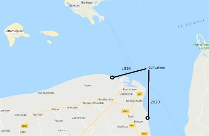
Locations of wave tanks
- Uithuizerwad sea dyke
- near Bierum
Organisation
The Noorderzijlvest Water Authority is the initiator and coordinator of the project. In August 2017, NZVset up anexpert group comprising experts from Deltares, the KNMI, and Rijkswaterstaat. The experts will assist NZV throughout the entire process to achieve the project objectives as efficientlyand effectively as possible.
In 2018, Noorderzijlvest conducted a tendering procedure based on the Best Value Procurement (BVP) method. The tender resulted in a consortium led by Arcadis being awarded the contract to carry out the field measurements. In addition to Arcadis (responsible for project management and the calculation models for water and wave movement), AquaVision (instrumentation and measurements), Infram-Hydren (wave run-up/overtopping), and Van der Meer Consulting (overtopping expertise) are also participating. In addition, there will be close cooperation on specific aspects with Rijkswaterstaat, Deltares, TU Delft, KNMI, and Groningen SeaPorts (GSP), among others. The contract with the consortium was signed on 28 September 2018.