
Phase 1 Peizerdiep stream valley
In Phase 1, we are working on measures in two subcatchments: Weehorst and Stenhorsten. Weehorst comprises the southern part of the area, and Stenhorsten the northern part. Depending on developments in the area, the remaining parts of the stream valley may also be redesigned in the future.
Measures in Stenhorsten
Stenhorsten subcatchment
The Stenhorsten subcatchment is located north of Peize, between the Peizerdiep and the N372. The following measures are being implemented in this area:
- Filling in or rerouting ditches
This allows water to be retained for longer. It improves the area’s “sponge effect” and raises groundwater levels within the nature reserves. In addition, filling in ditches helps retain water in the subsurface for longer during both wet and dry periods.
- Creating additional space for water from the Peizerdiep
By locally removing the existing flood embankments, water on the west side of the Peizerdiep flood embankment can flow to the east side. As a result, the nature areas on the east bank of the Peizerdiep will fluctuate in tandem with the water level in the Peizerdiep. This increases water storage capacity while also contributing to greater biodiversity in the area.
- Turfing work
The nutrient-rich topsoil is removed in specific areas so that new, species-rich natural habitats can develop. This enhances the area’s biodiversity.
- Restoration of ribbon vegetation and woodlands
Shrubs and trees are replanted along their original lines in the landscape. A new forest is also being planted.
- New pumping station along the N372
This pumping station will handle the daily drainage of water from the village of Peize. It will help improve drainage from Peize, which currently flows through the Noordseloop. During periods of high water levels, the pumping station can discharge extra water, helping to keep the water level stable. Its maximum capacity is 10 m³ per minute.
- New flood embankmen ts around two homes on Stenhorstdijk/Bommelier
New flood embankments are constructed around two homes on Stenhorstdijk. A small pumping station with a capacity of 0.45 m³ per minute will be installed to drain water.
Map Stenhorsten
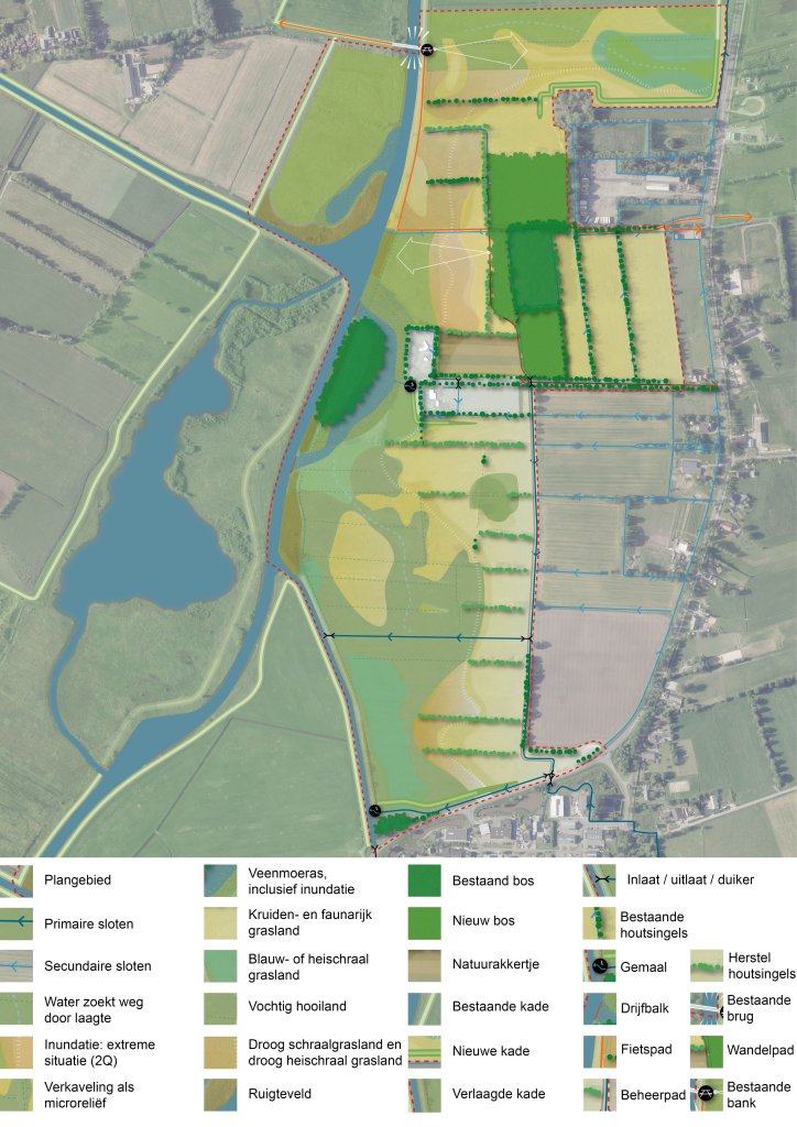
Map a planning area showing a proposed nature development plan. The map depicts existing agricultural parcels, watercourses built-up areas, combined with new habitat types such as grasslands, forests, wetlands, and water bodies. New and existing bike paths and other landscape features have also been added. At the bottom of the map is a legend explaining the colors and symbols used. If for any reason you are unable to read the map, please contact the water authority at m.bolkestein@noorderzijlvest.nl.
Weehorst measures
Weehorst subcatchment
The Weehorst subcatchment is located south of the N372 and north of the Sterrenbos weir. The following measures are being implemented here:
- Construction of a channel
The partially channeled Oude Diep near Weehorst is being converted into a channel. A channel is a shallow depression in the area that gradually drains water to lower-lying areas. Under normal conditions, the channel contains only groundwater and rainwater and has a natural character. During high water, the channel flows along with the floodwaters.
- Inlet and outlet in the flood embankment
To maintain a stable water level in the area, water may occasionally be let in or out under normal weather conditions. This allows for adjustments to prevent extreme waterlogging or drying out.
- Filling in or rerouting ditches
This helps retain water longer and improves the area’s “sponge effect.” It contributes to a more natural functioning of the water system.
- Turfing work
The nutrient-rich topsoil is removed so that new, species-rich natural habitats can develop. This enhances the area’s biodiversity.
- New bridge over the Weehorstweg
The Weehorstweg is being raised, and a new bridgewill be built over the ditch. This bridge will allow water to be drained from within the Weehorst area during high water. Under normal conditions, animals such as otters, small mammals, grass snakes, and amphibians can move safely through the area. The Weehorsterweg and the bridge will ensure that the residence remains easily accessible even when the Weehorst balancing lake is in use. Finally, the bridge offers a beautiful viewpoint for cyclists and walkers.
Map Weehorst
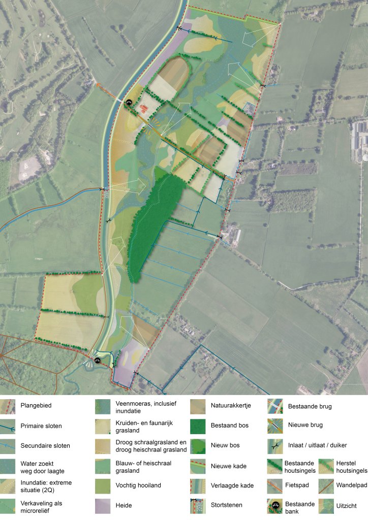
Map a planning area showing a proposed nature development plan. The map depicts existing agricultural parcels, watercourses built-up areas, combined with new habitat types such as grasslands, forests, wetlands, and water bodies. New and existing bike paths and other landscape features have also been added. At the bottom of the map is a legend explaining the colors and symbols used. If for any reason you are unable to read the map, please contact the water authority atm.bolkestein@noorderzijlvest.nl.